
Urban Climate Index
Barrios of València, August 2026
In the municipality, the August 2026 median surface was 38.8°C (28.4–53.4). The coldest pixel of the month (26.8°C, 17 August) sits in l’Albufera, outside the 81 barrios. The hottest (54.9°C, 16 August) falls on Benimàmet.
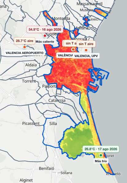
August 2026 composite. The green south is l’Albufera. The 26.8°C pin on 17 August sits there. The 54.9°C pin on 16 August falls on Benimàmet.
What the satellite sees and people do not inhabit
The municipality of València looks cool on the satellite because it includes l’Albufera, the green south. That cool is rice and lagoon. The city core sits apart.
Pinedo, to the south, still comes first in the index after the urban clip, because the remaining patches are huerta and village. The index ranks that heat. It does not crown Pinedo as a place to live. This cut is missing El Saler, El Palmar and El Perellonet, the lagoon hamlets.
The cooler built city
If Pinedo is set aside, the August index points to the newer east with some open ground, to the north of the Turia and to the gardens. Penya-roja sits at 41.1°C on average. Trinitat, at 41.2°C. El Botànic, at 41.3°C. Exposició and el Grau follow at 41.6°C; el Grau meets the port and its minimum reaches 30.6°C by the water.
El Pilar, el Mercat, el Carme, la Xerea and la Seu sit between 41.7 and 42.1°C: Ciutat Vella. That is the cooler built city of this August.
Cooler barrios. Urban Climate Index, municipality of València, August 2026.
| Rank | Barrio | Mean surface | Note |
|---|---|---|---|
| 1 | Pinedo | 36.6°C | Huerta and south. Leads after the urban clip. |
| 2 | Penya-roja | 41.1°C | East, newer, some open ground |
| 3 | Trinitat | 41.2°C | Turia / north |
| 4 | el Botànic | 41.3°C | Gardens and Turia |
| 5 | Exposició | 41.6°C | |
| 6 | el Grau | 41.6°C | Port; minimum 30.6°C by the water |
| 7–11 | el Pilar, el Mercat, el Carme, la Xerea, la Seu | 41.7–42.1°C | Ciutat Vella |
The hot west
The Patraix and Jesús strip is residential and industrial. Vara de Quart closes the index at 45.2°C on average. La Raïosa and el Calvari sit at 44.7°C. Borbotó and Beniferri, at 44.6°C. L’Hort de Senabre, Favara and Patraix follow at 44.2–44.4°C. That is the hottest ground in the city this August.
Hottest barrios. Urban Climate Index, municipality of València, August 2026.
| Rank | Barrio | Mean surface |
|---|---|---|
| 81 | Vara de Quart | 45.2°C |
| 80 | la Raïosa | 44.7°C |
| 79 | el Calvari | 44.7°C |
| 78 | Borbotó | 44.6°C |
| 77 | Beniferri | 44.6°C |
| 76 | Benimàmet | 45.0°C |
| 75 | l’Hort de Senabre | 44.4°C |
| 74 | Favara | 44.3°C |
| 73 | Patraix | 44.2°C |
Benimàmet and the airport station
Almost every barrio, 80 of 81, takes the València station in the centre: air at 28.6°C, humidity at 66%, 8.9 mm of rain and light wind. Only Benimàmet takes the airport station: air at 28.7°C, humidity at 58%, 24.5 mm and more wind.
Benimàmet has ground as hot as Vara de Quart, la Raïosa, el Calvari and Patraix, around 45.0°C, and the 54.9°C pin on 16 August. It sits 76th because it takes the airport station: drier air, more rain and more wind. The ground stays hot. The 24.5 mm is a couple of storms. It does not cool the monthly surface.
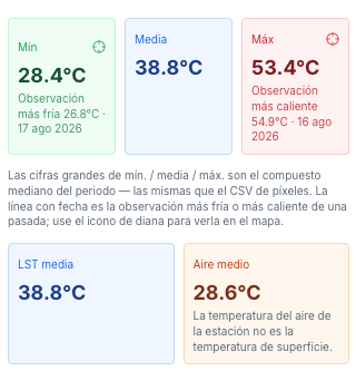
August composite: mean 38.8°C, minimum 28.4°C, maximum 53.4°C. The 26.8°C on 17 August and the 54.9°C on 16 August are single images, not the monthly mean.
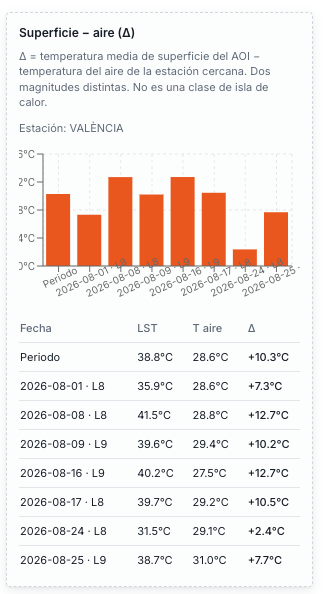
Surface and air are two magnitudes. At the València station the monthly mean sits 10.3°C above the air.
Russafa is not a refuge
Russafa sits 58th of 81, at 43.7°C on average, in the middle pack, with the humid air of the València station. Anyone looking for the cooler ground of this August in the built city looks toward Ciutat Vella, el Botànic and the Turia.
Method in four lines
Surface: Landsat composite for August, clipped to urban land. Air, humidity, rain and wind: two AEMET stations — 8416 València (city) and 8414A airport. Each barrio takes the nearest station that has that variable. There is no interpolated humidity or rain map.
The 81 barrios cover 82 km². The municipal outline is 139.5 km². The hole is mostly l’Albufera. Landsat is a composite of the month’s passes, not thirty daily readings.
How this relates to the metro
This URL is the municipality, 81 barrios. The metro area is another cut, another table, the same Urban Climate Index. Do not mix the two rankings. The metro cut will have its own URL.
Questions
Which barrio in València is hottest in August 2026?
Vara de Quart has the hottest mean urban surface, 45.2°C. Benimàmet holds the hottest single pixel, 54.9°C on 16 August, and sits 76th because it takes the airport station.
Is València a cool city in August?
The municipality looks cool because it includes l’Albufera. The built city sits around 41–45°C on the surface. The cool of August is the garden, the river and the lagoon.
Why does Pinedo come first?
After the urban clip, huerta and village remain. The 26.8°C pixel on 17 August sits in l’Albufera, outside the 81 barrios.
Does this say where to buy a flat?
No. The Urban Climate Index ranks the heat of one month. Rent, schools and the property market sit outside this reading.
This cut is one month. The weekly product for the town hall is Zeus, stations, and shade and water on the same map.