
Urban Climate Index
Urban Climate Index for Santa Marta, Colombia, in August 2026: heat across 272 zones
Written by Eduardo Garcia · Co-founder / CEO / CTOPublished 18 September 2026
#Urban-Climate-Index#Santa-Marta#Colombia#August-2026
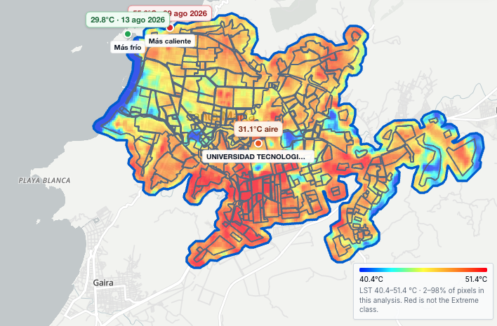
The urban continuum of Santa Marta, on the Caribbean. The meteorological station, Universidad Tecnológica on the map, reads 31.1°C air. This crop’s scale runs from 40.4°C to 51.4°C.
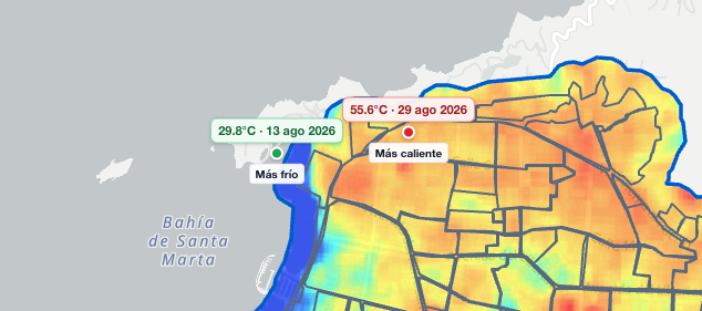
On 13 August the ground reached 29.8°C by Bahía de Santa Marta. On 29 August it reached 55.6°C. Both readings use the same scale.
The Urban Climate Index for Santa Marta, on the Caribbean, August 2026 combines land surface temperature on the urban continuum and official meteorological stations. This article is the cut of 272 zones on the urban continuum: neighbourhoods and other named places. It shows the five best and the five worst.
Cooler end of the ranking
Camellon leads on the bay edge, at about 37.3°C. Miramar and Edificio Bahia Linda follow. The best five:
Best five by the index. Urban Climate Index, Santa Marta, Colombia, August 2026.
| Rank | Zone | Surface |
|---|---|---|
| 1 | Camellon | 37.3°C |
| 2 | Miramar | 40.3°C |
| 3 | Edificio Bahia Linda | 40.8°C |
| 4 | Puerto Mosquito | 42.2°C |
| 5 | Quinta De San Pedro Alejandrino | 42.4°C |
Hotter end of the ranking
The inland ground closes the index. Luz Del Mundo is last of 272, at about 51.8°C. Cootransmag and Polideportivo del Sur sit in the worst five.
Worst five by the index. Urban Climate Index, Santa Marta, Colombia, August 2026.
| Rank | Zone | Surface |
|---|---|---|
| 272 | Luz Del Mundo | 51.8°C |
| 271 | Cootransmag | 51.8°C |
| 270 | Polideportivo del Sur | 51.6°C |
| 269 | Concepcion I | 51.5°C |
| 268 | El Trebol | 51.4°C |
Why the ranking follows the surface
All 272 zones take air, humidity and rain from the same IDEAM meteorological station, marked on the map as Universidad Tecnológica: 31.1°C air, 72.8% humidity, 35.6 mm of rain. The index uses both magnitudes, surface and air. This August the air does not change from one zone to the next, so the order follows the surface.
The composite of the urban continuum sits at 47.3°C, from 31.3°C to 55.1°C. One satellite image reached 29.8°C on 13 August and 55.6°C on 29 August. The monthly mean is that composite.
Pescaito sits in the middle of the index
Pescaito sits 133rd of 272, at about 47.6°C on average, in the middle pack. Centro sits 29th, at about 45.5°C. Anyone looking for cooler ground this August looks toward Camellon, Miramar and the bay edge.
How this August is built
This August is a composite of satellite data, the usable scenes after the cloud filter. Surface temperature and station air are two magnitudes; the index uses both. How it is calculated is on the index methodology.
Conclusion
In August the satellite sees a cooler bay edge and hotter inland ground. The mean of the urban continuum sits at 47.3°C.
Camellon leads and Luz Del Mundo closes.
Knowing this, where do you want to be next August in Santa Marta, on the Caribbean?
Questions
What is the Urban Climate Index in this text?
The August 2026 reading for Santa Marta, on the Caribbean: 272 zones, land surface temperature and official meteorological stations. This article shows the five best and the five worst; the full ranking downloads here.
Where is the full ranking?
The ranking of 272 downloads on this page: rank, zone and mean surface.
What is the 47.3°C on the cards?
The August composite for the whole urban continuum. The zone ranking uses that same area.
Why does the ranking follow the surface?
One meteorological station covers all 272 zones: 31.1°C air, 72.8% humidity, 35.6 mm of rain. Air does not set one zone apart from another this month, so the order follows the surface.
Where do Centro and Pescaito sit?
Centro sits 29th of 272, at about 45.5°C. Pescaito sits 133rd of 272, at about 47.6°C, in the middle pack.
Is this a liveability ranking?
The index ranks the climate of one August. Rent, schools and buying and selling sit outside.
Talk to us about the climate of your municipality
For another municipality, write with the area. We set up the surface map and the meteorological station reading.
Talk to us