
Urban Climate Index
Russafa, barrio of València, in August 2026
Written by Eduardo Garcia · Co-founder / CEO / CTOPublished 16 September 2026
#Urban-Climate-Index#València#Spain#August-2026
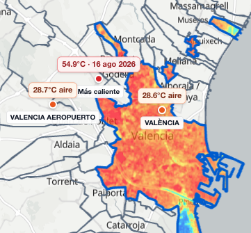
This map is the north of València, the city of streets and roofs. The colours show how hot the ground was in August, on the same scale as l’Albufera beside it.
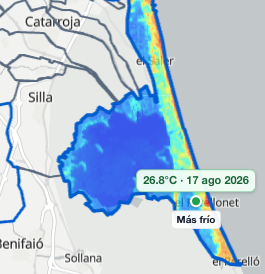
This map is the south of the municipality, l’Albufera, rice and lagoon. It shares the scale with the city, so the wetland ground reads cooler.
The Urban Climate Index for València, on the Mediterranean, ranks the heat of August 2026 across 81 barrios. The north is the city of streets and roofs and the south is l’Albufera. Here are the five coolest and the five hottest.
If you live here or you are considering it, you see which barrios ran cooler or hotter that August, and where you want to be.
The same index, across 45 municipalities in the metropolitan area, is another reading. Barrio and municipality are two cuts of the same index.
Cooler end of the ranking
Pinedo leads because huerta and village remain inside its polygon. In the built city, the cool sits toward the Turia, the gardens and Ciutat Vella. The best five:
Best five by the index. Urban Climate Index, València, August 2026.
| Rank | Barrio | Surface |
|---|---|---|
| 1 | Pinedo | 36.6°C |
| 2 | Penya-roja | 41.1°C |
| 3 | Trinitat | 41.2°C |
| 4 | el Botànic | 41.3°C |
| 5 | Exposició | 41.6°C |
Hotter end of the ranking
The inland west and the northern edge close the index. Vara de Quart is last. Borbotó sits in the worst five as a northern village. Benimàmet sits 76th: the ground is around 45°C, like Vara de Quart, and it takes air, humidity and rain from another meteorological station.
Worst five by the index. Urban Climate Index, València, August 2026.
| Rank | Barrio | Surface |
|---|---|---|
| 81 | Vara de Quart | 45.2°C |
| 80 | la Raïosa | 44.7°C |
| 79 | el Calvari | 44.7°C |
| 78 | Borbotó | 44.6°C |
| 77 | Beniferri | 44.6°C |
Why the ranking uses urban ground
L’Albufera is a wetland south of València: flooded rice and a lagoon. In August that ground stays cool because it is water and plant, not street. The barrio ranking uses urban ground so roofs and squares sit against roofs and squares. The whole municipality, lagoon included, sits at 38.8°C, from 28.4°C to 53.4°C. Pinedo still leads, at about 36.6°C, because huerta and village remain inside its polygon.
El Castellar - l'Oliveral sits 21st of 81, at about 42.5°C: it is a city barrio, and the huerta inside the boundary still cools the mean. El Saler, El Palmar and El Perellonet stay off the ranking: they are wetland villages, on rice and lagoon, not on the ground of the built city.
Benimàmet and the score
Benimàmet sits 76th of 81, mean surface about 45.0°C. Vara de Quart sits 81st at 45.2°C. The ground is equally hot. Benimàmet sits five places higher because it takes air, humidity and rain from another meteorological station: drier air, more rain. It is the only barrio that takes that station.
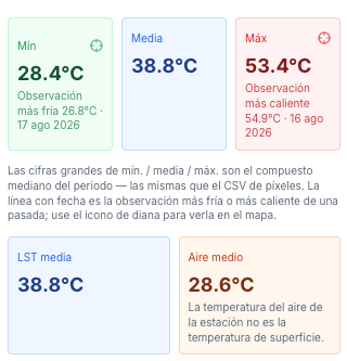
These figures are the August mean for the whole municipality, lagoon included: 38.8°C. A single satellite day can run cooler or hotter; the index uses the month.
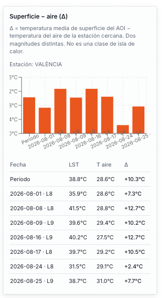
The ground sits hotter than the air: 38.8°C surface against 28.6°C. The index ranks with both readings.
Russafa sits in the middle of the index
Russafa sits 58th of 81, at about 43.7°C on average, in the middle pack. Anyone looking for cooler ground in the built city looks toward Ciutat Vella, el Botànic and the Turia.
How this August is built
This August brings together the usable satellite scenes after the cloud filter. Ground and station air are two different readings; the index uses both.
Other cities and months are on our blog.
Conclusion
In August the satellite sees a hot built city and a cooler l’Albufera, rice and lagoon. The mean of the whole municipality, lagoon included, sits at 38.8°C.
Pinedo leads and Vara de Quart closes.
Knowing this, where do you want to be next August in Valencia, on the Mediterranean?
Questions
What do I do with this ranking?
It ranks that August’s climate for people who live here or are considering it. Rent and schools sit outside the score. The question is where you want to be next August.
What is the Urban Climate Index in this text?
The August 2026 reading for the municipality of València: 81 barrios, land surface temperature and official meteorological stations. This article shows the five best and the five worst; the full ranking downloads here.
Where is the full ranking?
The ranking of 81 downloads on this page: rank, barrio and mean surface.
What is the 38.8°C on the cards?
The August mean for the whole municipality, lagoon included. L’Albufera is water and rice; that mean does not count the heat of the streets. The barrio ranking uses urban ground.
Why does El Castellar sit 21st of 81?
It is a city barrio. Huerta inside the boundary still cools the mean, at about 42.5°C, 21st of 81. El Saler, El Palmar and El Perellonet stay off the ranking: they are wetland villages, on rice and lagoon, not on the ground of the built city.
Why does Benimàmet sit 76th of 81?
Ground around 45.0°C, as hot as the west, and a lower score than Vara de Quart because it takes air, humidity and rain from another meteorological station: about 58.2% humidity and 24.5 mm of rain, against 65.8% and 8.9 mm on the central station.
Talk to us about the climate of your city
If your city is not here, write with the place. We set up the ranking of barrios or zones.
Talk to us