
Urban Climate Index
Urban Climate Index for the València metropolitan area in August 2026: heat across 45 municipalities
Written by Eduardo Garcia · Co-founder / CEO / CTOPublished 16 September 2026
#Urban-Climate-Index#València#August-2026#metropolitan-area
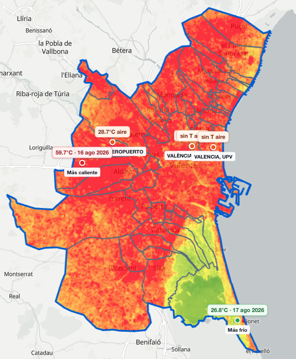
The metropolitan area. Ground reached 59.7°C on 16 August by the airport. L’Albufera sat at 26.8°C on 17 August. The map marks two meteorological stations: València, in the city, and the airport. Each municipality takes the air from one of the two.
The Urban Climate Index for the València metropolitan area, August 2026 combines land surface temperature on urban ground and official meteorological stations. This article is the metropolitan cut: 45 municipalities. It shows the five best and the five worst.
The same index, across 81 barrios of the municipality of València, is another reading. Barrio and municipality are two cuts of the same index.
The August score brings together ground temperature with air, humidity and rain from meteorological stations. In a hot month, a lower score is more comfortable. How it is calculated is on the index methodology.
Cooler end of the ranking
València leads because the Turia, the gardens and huerta remain on urban ground. Alfafar sits second, still next to l’Albufera. The best five:
Best five by the index. Urban Climate Index, València metropolitan area, August 2026.
| Rank | Municipality | Surface |
|---|---|---|
| 1 | València | 38.1°C |
| 2 | Alfafar | 41.5°C |
| 3 | Picassent | 41.9°C |
| 4 | La Pobla de Farnals | 41.9°C |
| 5 | Torrent | 42.2°C |
Hotter end of the ranking
The inland west closes the index. Aldaia is last of 45, at about 46.1°C. Alaquàs and Quart de Poblet sit in the worst five, also to the west. Rafelbunyol, a municipality in the north, sits 42nd of 45, at about 45.4°C. Beniparrell, to the south, sits 43rd of 45, at about 45.5°C.
Worst five by the index. Urban Climate Index, València metropolitan area, August 2026.
| Rank | Municipality | Surface |
|---|---|---|
| 45 | Aldaia | 46.1°C |
| 44 | Alaquàs | 46.0°C |
| 43 | Beniparrell | 45.5°C |
| 42 | Rafelbunyol | 45.4°C |
| 41 | Quart de Poblet | 45.2°C |
Why the ranking uses urban ground
L’Albufera is a wetland to the south: flooded rice and a lagoon. In August that ground stays cool because it is water and plant, not street. The ranking of municipalities uses urban ground. The metropolitan area, lagoon included, sits at 41.7°C, from 28.4°C to 56.6°C.
Alfafar, Massanassa, Silla and Catarroja look cool while the rice sits inside the mean. Alfafar moves from about 35.9°C to about 41.5°C and sits 2nd of 45. Massanassa sits 17th of 45. Catarroja sits 33rd of 45. València, at about 38.1°C on urban ground, sits 1st of 45.
Why Picassent sits 3rd and Aldaia 45th
Two meteorological stations cover the 45 municipalities. Thirty three read the air in València: damper, less rain. Twelve read it at the airport: drier, 24.5 mm of rain against 8.9 mm.
Picassent and Aldaia read the airport. Picassent’s ground sits around 41.9°C and Aldaia’s around 46.1°C. That is why Picassent sits 3rd of 45 and Aldaia last. Torrent reads the same airport and sits 5th of 45.
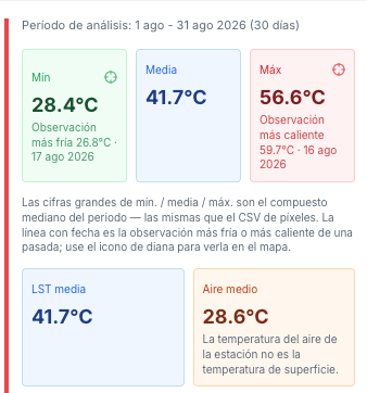
August composite for the area: mean 41.7°C, from 28.4°C to 56.6°C. One satellite image reached 26.8°C on 17 August and 59.7°C on 16 August. The monthly mean is that composite.
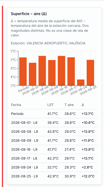
On the area composite the surface sits 13.1°C above the air, 41.7°C against 28.6°C. The gap changes from one satellite image to the next. The index uses both magnitudes.
Mislata sits in the middle of the index
Mislata sits 29th of 45, at about 44.1°C on average, in the middle pack. Anyone looking for cooler ground in the built area looks toward València, Alfafar and the edge of l’Albufera.
Conclusion
In August the satellite sees a hot metropolitan west and a cooler l’Albufera, rice and lagoon. The mean of the whole area, lagoon included, sits at 41.7°C.
València leads and Aldaia closes.
Knowing this, where do you want to be next August in the València metropolitan area?
Questions
What is the Urban Climate Index in this text?
The August 2026 reading for the València metropolitan area: 45 municipalities, land surface temperature and official meteorological stations. This article shows the five best and the five worst; the full ranking downloads here.
Where is the full ranking?
The ranking of 45 downloads on this page: rank, municipality and mean surface. HTML cuts sit on the Urban Climate Index.
What is the 41.7°C on the cards?
The August composite for the whole metropolitan area, lagoon included. L’Albufera is water and rice; that mean does not count the heat of the streets. The ranking of municipalities uses urban ground.
Why does València lead and Alfafar not?
Alfafar, Massanassa, Silla and Catarroja come in cool while the rice counts in the mean. On urban ground, Alfafar sits 2nd of 45, at about 41.5°C, and València sits 1st of 45, at about 38.1°C, with the Turia and the gardens.
Why does Picassent sit 3rd and Aldaia 45th?
Both read the air at the airport: drier, and 24.5 mm of rain. Picassent’s ground sits around 41.9°C and Aldaia’s around 46.1°C. That is why Picassent sits 3rd of 45 and Aldaia 45th of 45.
Is this a liveability ranking?
The index ranks the climate of one August. Rent, schools and buying and selling sit outside.
Talk to us about the climate of your municipality
For another municipality, write with the area. We set up the surface map and the meteorological station reading.
Talk to us